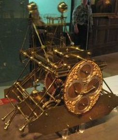
 First version of the Harrison clock, 1736, Wikipedia
 (Let cursor hover over pictures above to see captions. Click image to enlarge.)
Roger M McCoy
We often read accounts of early explorers sailing to unknown lands in the New World, but we seldom learn about the art of navigating ships into the uncharted parts of the world with full confidence in finding the way home. Would they even have started if they thought they could not return? How did they do it?
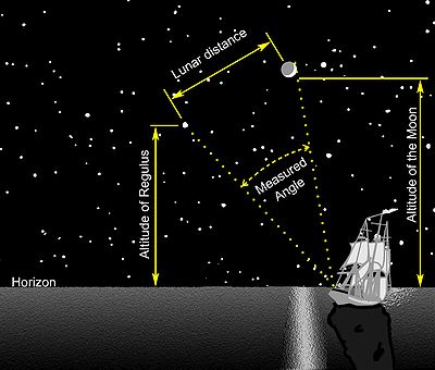
Mariners first learned the skill of navigating by dead reckoning. To estimate their position by dead reckoning mariners must have some idea of speed, time lapsed at that speed, and direction of travel. They started from a port with a known latitude and longitude that astronomers had calculated by a complicated method known as lunar distance. From that known point mariners had to continually estimate their speed, time, and direction to determine their current location. You can imagine the potential for cumulative error using dead reckoning at sea for months at a time. Their skill, however, was astonishing. We may see big errors in their maps; but overlooking the errors, the surprise is that they were even in the ball park.
The development of navigational instruments was merely an attempt to refine the estimates of direction (the compass), speed (the chip log), and time (the sand glass to measure short times, e.g., 30 seconds). Instruments for measuring angles of stars or the Sun above the horizon also became important for estimating latitude (parallels) north or south of the equator. But estimates of longitude (meridians) at sea relied on dead reckoning until the late eighteenth century.
Early Greek sailors noticed that stars in the northernmost quarter of the sky merely rotated like a wheel without setting below the horizon. Their greatest interest was in a constellation made of seven stars, because of their high visibility and their nearness to the pivot point. This constellation was called variously, the Bear, the Plow, the Seven Oxen, or the Wain (wagon). Today we call it the Big Dipper or Ursa Major (Great Bear). The Little Dipper or Ursa Minor (Lesser Bear) being closer to the point of the turning axis, later became more important to navigators.
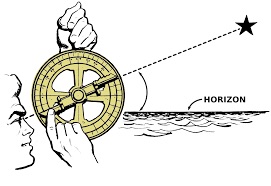
Measuring Angles. To aid in observations of angles a simple measuring instrument, the astrolabe, was developed. Although the astrolabe was developed around 200 B.C. as an aid to astrology, its application to navigation by European mariners probably began in the fifteenth century A.D.
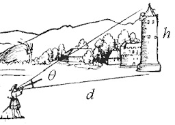
Improvements in the fourteenth century lead to the development of the cross-staff, which consisted of a wooden staff with a sliding cross-piece set perpendicular to it . A navigator would move the cross piece along the staff to a mark for the desired latitude, then sail north or south along a meridian until the perpendicular cross bar just fit between the horizon and the Pole Star (or the sun by day). He would then be at the latitude of his intended location, and could then sail along that course by compass to his destination. Frequent checks by astrolabe helped indicate any variation in latitude. This method of navigation, called “running down the latitude,” was in practice for many Atlantic crossings in the sixteenth and seventeenth centuries. During the day, the navigator would measure the angle of the noon sun above the horizon to compute latitude. This computation required knowing the latitude where the sun was directly overhead at noon on any given day of the year. In the fifteenth century this information was widely available to mariners in tables or diagrams compiled by astronomers.
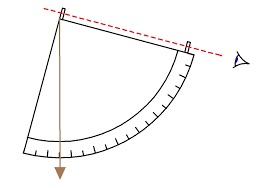
Another early angle measuring instrument was the quadrant, so named because it was one quarter of a circle. By the middle of the fifteenth century the quadrant was in use for measuring celestial angles aboard ships. Variations on the quadrant—including octants and sextants—gradually became more sophisticated with sun filters, mirrors, and sliding scales graduated in degrees. The sextant continued in use for navigation well into the twentieth century until inertial guidance and satellite positioning systems appeared.
Determining Direction. Soon after 1100 A. D. the unusual properties of a common iron oxide mineral called magnetite (lodestone) became known to Mediterranean sailors. Bewildered observers saw that magnetite would align itself with north. This was a mysterious phenomenon because nothing was yet known of Earth’s magnetic field. They also found that rubbing an iron needle against the lodestone passed the mysterious property to the needle. By sticking the needle through a piece of straw it would float in a bowl of water, then the needle would orient itself toward the north. The fact that the needle would point approximately north could not be explained except by some force in the polar constellations acting on the lodestone or on the needle that had touched it. As Polaris was within six degrees of the stellar rotation axis and appeared to be motionless while other stars circled around. This made Polaris of much greater potential importance to navigators.Mariners did not adopt the magnetic needle quickly, but gradually began to use it only when visual methods failed, as during cloudy weather.
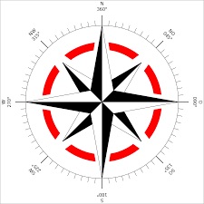
In order to protect the needle from wind and make it visible at night, the floating needle was put into a protective housing with a lamp, and thus the binnacle was created and is still in use today. For greater precision the compass must be something more than a needle floating in a bowl of water. Instrument makers by the end of the twelfth century had balanced the needle on a metal pivot point overlying a thirty-two point compass rose enclosed in the binnacle, and the modern compass was born.
Distance. Now the mariner had the essential tools for navigation—astrolabe or quadrant, compass, and a sand glass for keeping time—essential for estimating distance. The other critical component of distance computation is speed.
Distance traveled was a crucial bit of information for a seaman. He needed distance to estimate position and his rate of progress toward his destination. The only means available was “dead reckoning”—estimating the speed of the ship over a period of time. Remember that speed multiplied by time equals distance. Early navigators could make reasonable guesses of their ships’ speed by the feel of its movement through the water. Earliest estimates were made by pacing the deck alongside a small object thrown overboard and judging the rate of walking. A new device for estimating speed appeared in 1574—the log and lines.
A piece of wood, originally a log, was tied to a long knotted cord and thrown overboard beyond the dead water at the stern of the ship. The log would remain roughly in place while the vessel moved away. A sailor counted the knots that paid out in thirty seconds, timing with a small sandglass, as the ship moved away from the log—clearly a two-man job. They counted the small uniformly spaced knots to measure the length of cord paid out in thirty seconds. The result was expressed as knots per hour. This procedure was repeated anytime the ship changed speed or course. The log was eventually modified to a small triangular, board, called a chip log, This method of measuring speed was a big improvement over former guesswork, but was also subject to error.
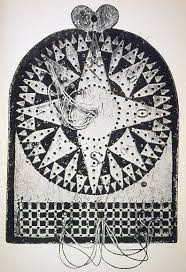
The speed and direction information was pegged on a traverse board, transferred to the log book and used for estimating distance traveled. The traverse board had a thirty-two point compass rose drawn on its face with radial rows of eight holes along each of the thirty-two compass points. For each half-hour of a four hour watch, the helmsman inserted a peg in a hole of the compass direction they were traveling, beginning with the innermost hole and working outward. At the end of a four hour watch, all this direction and speed information was recorded in the log book and used to compute distance made good.
Because a ship sailing into the wind must tack back and forth rather than maintain a straight course to its destination, a navigator had to keep track of their actual location as well as their progress along the intended course, called “distance made good.” By plotting their location on the actual line of sail and drawing a perpendicular connection from that point to the line of the intended course, the distance made good is determined.
The relationship between longitude and the steady turning of Earth at fifteen degrees per hour was well known, and by the early sixteenth century some navigators knew that a trustworthy clock at sea would solve the problem of finding longitude. If a navigator had a reliable clock set to the time at a place of known longitude, he could determine his local time by the sun and find the exact time difference. Fifteen degrees for each hour of time difference allowed easy computation of longitude. In the beginning, and through the Renaissance, every seafaring nation determined its own choice of a prime meridian as a starting point. Over time there have been many including an island of the Canaries, an island of the Azores, Paris, Greenwich, Brussels, Oslo, Rome, Florence, St. Petersburg, and others. Eventually the British published a comprehensive set of tables for calculating longitude using lunar angles based on the meridian at Greenwich. These tables became widely used and in the eighteenth century the Greenwich meridian became the world standard.
It was the middle of the eighteenth century before John Harrison, an English carpenter and clock maker, undertook the challenge to create a ship’s clock with the needed accuracy. Many leading scientists of the eighteenth century still believed that a clock of such accuracy could never be made, so they pushed for greater application of the astronomical angles method of time telling. Finally in 1761 Harrison’s efforts produced a clock that passed a prescribed test by accurately determining longitude during a voyage. The clock evolved through several stages from a cumbersome machine the size of a large mantle clock to one that looked like an oversized pocket watch. With each iteration the design and accuracy improved. Unfortunately for Harrison, the judges were primarily proponents of the astronomical approach, and they denied him the £20,000 prize money because the success was deemed to have been a bit of good luck—a coincidence. Eventually the voyage was repeated, and Harrison created new versions of the clock—a total of five— before he finally received the last of the prize money more than a decade later in 1775, the year before he died.
Like many useful innovations, adoption of Harrison’s clock was slow but by the middle of the nineteenth century, ships leaving London via the Thames River paused within sight of the Greenwich observatory to set their chronometers with the time-ball that fell at 1:00 P. M. daily. In the early 1920’s the ball drop was superseded by a radio time signal, which in turn has been replaced by the atomic clocks in the Global Positioning Satellite System. These innovations for finding position changed traditional navigation methods that had been used for centuries. Despite these more accurate means, the old method of finding location using clocks and sextants is still part of a navigator’s training.
Sources
May, William E. A History of Marine Navigation, Henley-on Thames: G. T. Foulis and Co., 1973.
Taylor, E. G. R. The Haven Finding Art: A History of Navigation from Odysseus to Captain Cook. New York: Abelard - Schuman, Ltd, 1957.
Waters, David. The Art of Navigation in Elizabethan and Early Stuart Times. Greenwich, England: National Maritime Museum, 1978.
