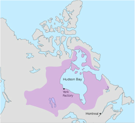
 Rupert's Land was defined by the area of drainage into Hudson Bay. Wikimedia.
Roger M. McCoy
We often read that a country sent explorers to claim land in the name of the king, and it would be easy to assume that country’s monarch paid all the bills for the expedition. Not so. Sometimes the monarch provided nothing, or perhaps a ship. The king’s main role was to provide permission for such a venture to occur. Without that permission, called “letters patent,” the voyage was illegal and the explorer could be punished when he returned. So who provided all the money and additional ships?
Enterprising men developed several approaches to funding. For example, John Cabot received letters patent from the king authorizing him to sail to North America (see Explorer’s Tales 11/1/14). The task of raising money was Cabot’s responsibility, but he found a group of businessmen in the port city of Bristol, England who were eager to invest in a search for the Northwest Passage. King Henry VII granted permission to explore and claim lands not governed by a Christian prince, and also allowed Cabot and his financiers to reap the profits of their endeavor. In addition the king granted Cabot a handsome stipend, which, of course the merchants...not the king...had to pay. Also, the king was to receive two-tenths share of all profit from the venture. In short, the king would have fared extremely well without making any investment. This is, of course, a good example of “It’s good to be the king.” (Thanks, Mel Brooks.)
Giovanni Verrazzano sailed to North America under a similar arrangement funded by a group of bankers and merchants in Lyon, France. King Francis the First granted permission for an expedition of four ships, one of which came from his navy, but provided no money. Verrazzano was granted the right to be governor of any new colonies and retain a one-tenth part of gold, silver, spices, and all other valuable goods extracted from the new lands. This too resulted in nothing but losses for the bankers and merchants who made the investment.
The next stage of exploration financing arrangements was the creation of chartered trading companies that conducted exploration as a means of expanding their trading rights. For example, the Muscovy Company, or Russian Company, was chartered by Queen Elizabeth I in 1555, and had a monopoly on trade between England and Russia until 1698. It survived as a trading company until the Russian Revolution in 1917. The Muscovy Company was the first major joint stock company and the precursor of that type of business. In the interest of expanding trade, the Muscovy Company unsuccessfully explored possible routes to Asia in the seas north of Russia.
When Martin Frobisher sailed to North America under Queen Elizabeth I in 1576, the Cathay Company, an offshoot of the Muscovy Company, was formed by Michael Lok (see Explorer’s Tales 8/18/14 & 9/1/14). The Cathay Company was granted a royal charter to explore westward to develop trade with new lands and to search for the Northwest Passage to Asia. The Cathay Company solicited a broad range of investors, including many private citizens with small amounts of money, in order to finance Frobisher’s voyage. The Queen herself invested £4,000, and some of her cabinet members also put in hefty sums. In this model of finance Queen Elizabeth granted the original charter for “The Company of Cathay,” and also bought shares. Frobisher discovered what he mistakenly declared to be the Passage and brought home shiploads of supposed gold ore. Unfortunately, the “gold ore” proved to be marcasite, an iron disulfide mineral with a yellow gold appearance similar to pyrite. The investors received nothing, which put a damper on Frobisher’s career for a time, but totally ruined poor Michael Lok who ended up in debtor’s prison.
The chartered company model reached its zenith in the seventeenth century with the formation of the East India Company in 1600 and the Hudson’s Bay Company in 1670. A basic difference for these companies was that they each became managers of vast lands and actually occupied their respective holdings. The Hudson’s Bay Company became a major player in the exploration of their holdings, covering approximately one-third of present-day Canada plus a small portion of an area later to become part of the United States.
“The Governor and Company of Adventurers of England Trading into Hudson's Bay,” usually called the Hudson’s Bay Company, was incorporated with a royal charter granting the company a monopoly over all the region drained by rivers and streams flowing into Hudson Bay. This vast area was called Rupert's Land after Prince Rupert, who was the first governor of the company, and coincidentally a cousin of King Charles II. The specific boundaries of Rupert’s Land were unknown at the time, hence an incentive for exploration. The Hudson’s Bay Company was at one time the largest landowner in the world. From its headquarters in York Factory on Hudson Bay, the company controlled the fur trade throughout much of the British-controlled North America for almost two centuries. (The term “factory” referred to an establishment carrying on business in a foreign country.)
The 1670 charter document specified the purpose of the Hudson’s Bay Company was: the discovery of a new Passage into the South Sea and for the finding some Trade for Furrs Mineralls and other considerable Commodityes and by such theire undertaking have already made such discoveryes as doe encourage them to proceed further in pursuance of theire said designe by meanes whereof there may probably arise very great advantage to us and our Kingdome. Emphasis was on furs, minerals, and a passage to the Orient. Exploration therefore was an important part of their function as a means of expanding fur trade, searching for mineral wealth, and finding the all-important passage. The Hudson’s Bay Company had an enormous influence on the early development in the northern parts of North America.
The Hudson’s Bay Company had several illicit competitors who regarded the HBC’s Royal Charter as only a minor annoyance. One of these competitors was the North West Company, which was formed in 1779 in Montreal as a coalition of several Canadian fur traders who were hurt by the HBC monopoly. They soon became a significant competitor to the HBC. This intruder company had no charter or real legal basis for trapping, trading, and exploring in Rupert’s Land, but in such a remote area it was difficult to enforce the law. The competition became intense and occasionally led to open warfare. North West Company often set up trading posts adjacent to those of the Hudson’s Bay Company and were often successful in drawing fur trade away. Each company even minted its own money.
The North West Company was at a distinct disadvantage in competing with the Hudson's Bay Company, whose charter assured it a monopoly. The North West company tried to persuade the British Parliament to change arrangements so the North West Company could at least have transit rights to ship goods and supplies, but all requests were refused. In the early nineteenth century the beaver supply began to diminish, creating even sharper competition. This however, did not keep them from operating. They continued their competitive race until 1821 when the two merged and the North West Company disappeared. Today the Hudson’s Bay Company is not in the fur trade business, but is a diversified company operating many department stores under their own name and has acquired restaurant chains, credit card businesses, car rental chains, etc., plus other mercantile businesses, e.g. New York’s Saks Corporation and Lord & Taylor department stores.
The Hudson’s Bay Company and the North West Company each contributed greatly to the exploration and discovery of Canada with extremely competent men who knew how to survive in the harsh Arctic environments. Part two of this subject will give information on a few of the hardy company explorers such as Samuel Hearne, Alexander MacKenzie, Peter Deese, and John Rae and how they learned to survive/thrive in the Arctic.