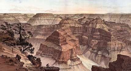
 Grand Canyon from Point Sublime. W.H. Holmes, artist.
 Roger M. McCoy
The previous blog on artists’ discovery of the West (Jan 22, 2015), showed that artists with formal training in the art styles of Europe produced many paintings of their impressions of the land. They successfully portrayed a romantic sensation of vast scale and luminous atmosphere, and their work became widely popular. However, these impressionistic paintings lacked one important quality, i.e. accuracy. The scientists on these 19th century survey expeditions needed more realism in the presentation of topography, plants, animals, and fossils.
The scientists accompanying explorers to the West had one significant problem that could not be solved by written reports alone. Their observations required graphics with a reliable amount of accuracy. One old and useful graphic was, of course, the map, and these new explorer/scientists had the instruments and skills to produce reliable maps of routes and topography. In addition to maps, these enterprising men devised or invented new ways of portraying the landscape in a scientifically useful way. Their need led to the development of incredibly detailed drawings of fossils, plants, animals, and vast panoramic landscapes that were more useful and exact than photographs. Cameras of the day were inadequate to the task of showing details in views of canyons, plants, or animals. Even today an illustration may often be preferable to a photograph for certain details. Geologic maps, cross-sections of strata, and panoramas of landforms produced a trove of documentary art. This type of art also influenced the work of conventional artists and thus became an important part of the story of American art and Western exploration. The following artists, better described as scientific illustrators, are examples of those who went on western exploration expeditions and produced extraordinary work.
The most notable of the scientific illustrators/cartographers was William H. Holmes (1846-1933). As an art student in Washington D.C. his skills soon came to the attention of scientists at the Smithsonian, and in 1872, at age 26, he became the artist/topographer with the Hayden survey of the newly created Yellowstone National Park. A peak in the park is now named Mount Holmes in his honor. In 1882 Holmes, by then an employee of the U.S.G.S., illustrated the atlas for a major survey of the geology of the Grand Canyon District under well-known geologist Clarence Dutton. Holmes’s stunning depictions of the canyon are available in libraries that have a complete section of government documents, or from some print sellers, but surprisingly they are not seen in museums.
John E. Weyss (1820-1903) was an Austrian-born American artist/cartographer with the U.S. Topographical Engineers. He was producing detailed maps for the War Department during the Civil War, but his finest topographic maps were those showing the topography of Yosemite Valley with the use of hachures, closely spaced lines to depict steepness and orientation of slopes. The Weyss Yosemite map is a beautiful rendition of topography derived from many field sketches, some photographs, and a few elevation points, obtained with barometric altimeters. It was published as part of the Topographical Atlas contained the survey called “West of the 100th Meridian of Longitude,” also known as the Wheeler Survey (1871-1876), which was one of the most important surveys of the American West.
Robert P. Whitfield (1828-1910) was a paleontologist and geology professor at Rensselaer Polytechnic Institute before becoming geological curator of the American Museum of Natural History. His research had produced many publications on the fossils of New York. These credentials earned him an place as paleontologist on the Fortieth Parallel Survey led by Clarence King. This important survey covered areas along the 40th parallel including parts of California, Nevada, Utah, Wyoming, and Colorado.
The slide show below shows the works of these and other illustrators.
The following notes replace captions.
1. Sunset on the Kanab Desert. View from the brink of the Permian Cliff - the butte in the foreground, the Vermillion Cliffs in the distance, and the Jurassic white sandstone in the extreme background. Drawn by W. H. Holmes. Grand Canyon District, Mohave County, Arizona . Circa 1877. USGS library
2. Panorama from Point Sublime, illustration of the Grand Canyon by W. H. Holmes, published in: Clarence E. Dutton, The Tertiary History of the Grand Cañon District (1882), sheet XV.
3. Grand Canyon at the Foot of the Toroweap Looking East. by W. H. Holmes. sheet VI, in: Clarence E. Dutton, The Tertiary History of the Grand Cañon District (1882).
4. Field sketch of Mesa Verde by W. H. Holmes in 1876 with the Hayden party.
5. The Temples and Towers of the Virgen (Virgin) in the canyons of present day Zion Park. By W. H. Holmes. From Clarence Dutton’s Tertiary History of the Grand Canyon District.
6. Topographical Map of the Yosemite Valley and Vicinity, by Major John E. Weyss of the U. S. Topographical Engineers (1871-1876). This first detailed survey of Yosemite Valley shows interesting cultural features in the valley, many of which no longer exist. The steep valley cliffs are shown with a map style begun in the 19th century called hachuring with closely spaced lines to indicate steepness and orientation of slope. This map was published as part of the Topographical Atlas in West of the 100th Meridian of Longitude, also known as the Wheeler Survey.
7. Detail of Topographical Map of the Yosemite Valley and Vicinity, by Major John E. Weyss showing hachures and cultural features with spot elevations.
8. Detail of Topographical Map of the Yosemite Valley and Vicinity, by Major John E. Weyss.
9. Bird’s-eye view of the Black Hills by Henry Newton, in Geographical and Geological Survey of the Rocky Mountain Region, 1875, a report on the Henry Newton/Walter Jenny scientific expedition to the Black Hills,
10. Illustration from Fossils of the Black Hills by R. P. Whitfield in Geographical and Geological Survey of the Rocky Mountain Region, 1875, a report on the Henry Newton/Walter Jenny scientific expedition to the Black Hills,
11. Group photo of Hayden Survey party in Wyoming 1870. The party of about forty men included two cooks, two artists, a naturalist, zoologist, meteorologist, agriculturist, mineralogist, and one hunter. F.V. Hayden is seated, hatless, with beard, wearing coat. Far left standing is a cook known as “Potato John." Photographer William H. Jackson.
