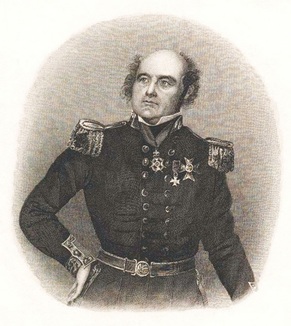
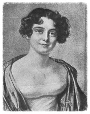
New World Exploration
Contact
  • Explorers' Tales Blog
  • Bibliography
  • Contact

Sir John Franklin: The failed hero. Part 3

10/1/2015

2 Comments

 
Picture
Sir John Franklin
Picture
Lady Jane Franklin

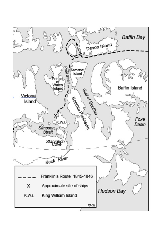
Recap: In 1857, twelve years after the expedition left England, the relentless Lady Jane Franklin sent M’Clintock to search for her husband, Sir John Franklin, near King William Island.

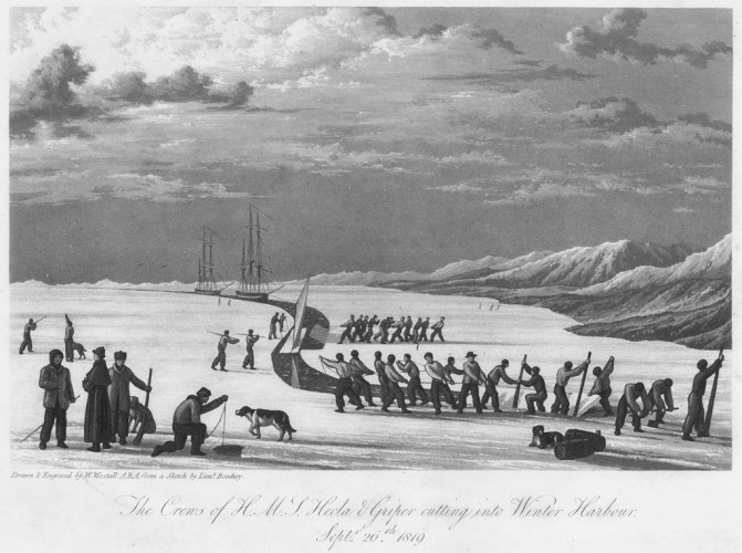
    M’Clintock’s expedition split into two parties taking different routes toward King William Island. Each party consisted of teams of six to eight men harnessed to heavy sledges, each loaded with eight hundred pounds of cargo. They could average ten or twelve miles per day over the relatively smooth surface of the frozen sea and go where no ship could sail.  
    Eventually M’Clintock’s party came upon a rock cairn containing this ominous message:

April 25, 1848 — H. M. ships, Terror and Erebus were deserted on the 22nd April 5 leagues N.N.W. of this, having been beset since 12th September, 1846. The officers and crews consisting of 105 souls, under the command of F. R. M. Crozier, landed here. Sir John Franklin died on the 11th June, 1847; and the total loss by deaths in the expedition has been to this date 9 officers and 15 men.
F. R. M. Crozier                    James Fitzjames
Captain and Senior Officer                Captain H. M. S. Erebus.
start tomorrow, 26th, for Back’s Fish River.


Apparently Captain Crozier, who took command when Franklin died, had abandoned the expedition and tried to take his 105 starving men to a place of refuge. The nearest such destination was a Hudson Bay Company post on the Great Slave Lake, more than 1,000 miles away. The company of the Erebus and Terror must have been on reduced rations for much of the winter of 1847-48, and the men already wasted enough to be in weakened condition before they left the ships.
    Traveling along the west coast of King William Island, M’Clintock found relics of the expedition, including a twenty-eight foot boat mounted on a sledge that the escaping men had brought only a short distance. A large quantity of tattered clothing lay in the boat, and portions of two human skeletons. The boat weighed about eight hundred pounds and when mounted on the heavy sledge made a 1,400 pound dead weight for the weakened men to pull. Sledging with such an incredible weight went against all that had been learned up to that time about travel in the Arctic where survival depended upon traveling light. Besides the provisions they could muster, the survivors had carried almost anything of value, including silver table service and an “amazing quantity of clothing”—of no use to their survival.
    Other items found in the boat included five watches, two double-barreled guns— one barrel in each of them was loaded and cocked. Several small books were found, including The Vicar of Wakefield, and scriptural or devotional readings. A brief listing of the items M’Clintock found serves to illustrate their seeming lack of awareness of the dire situation they faced. He saw different types of boots, such as sea boots, cloth winter boots, heavy ankle boots, shoes, silk handkerchiefs, towels, soap, toothbrushes, and combs. Other items included twine, nails, saws, files, bristles, wax ends, sailmakers’ palms, powder, bullets, shot, cartridges, knives (including dinner knives), needle and thread cases, and two rolls of sheet lead. The guns, bullets, powder, and hunting knives would have been essential if they found game. M’Clintock found a bit of tea and forty pounds of chocolate but no biscuits or meat. Also in the boat were eleven large silver spoons, four silver teaspoons, and eleven silver forks, all bearing crests of Franklin or one of the  other officers, but no iron spoons of the type issued to seamen. Apparently desperation forced the  men to abandon the heavily loaded sledge and continue only with what they could carry.
    The emerging story from M’Clintock and various later accounts remains hazy, but certain elements are firm. One hundred five men from the two ships had set off for the Great Slave Lake via Back River. As they reached Terror Bay, only twenty-five miles from their abandoned ships, the crewmen, weak from hunger and scurvy, had already begun to falter under their heavy loads. They apparently camped for several days to recuperate. Later searchers found several skeletons and two boats in addition to the one found by M’Clintock. Physical evidence suggests that Captain Crozier and any men strong enough to move continued south toward the Back River. As the group slowly moved along the south coast of King William Island, fallen men and abandoned equipment marked their route. At some point the group split and took different directions, probably hoping that at least one would reach help. Crozier’s group of about forty men continued toward the Back River.  A second group headed east toward Boothia Peninsula, perhaps hoping to reach open water and intercept a rescue ship. Whatever their expectation, they failed and died.
    Meanwhile, Crozier’s dwindling party crossed Simpson Strait on the ice and reached the mainland. Sometime, possibly as much as three years later, Eskimos found bodies of thirty men at a small bay on the north coast of Adelaide, now called Starvation Cove. They had traveled nearly one hundred fifty miles from the ships, almost reaching the estuary of the Back River. The Eskimos’ account revealed that the corpses had been eaten by humans. They said that bones had been cut through by saws, and skulls had been broken open to remove the brains. Also, the Eskimos found many papers, probably records of the expedition. Having no value to the Eskimos, the papers were discarded and lost forever.
    Franklin’s starving men purposely had avoided contact with Eskimos who could have helped the stranded mariners survive. The crewmen had persisted in living as Europeans who saw no reason to learn from an uncivilized people about living in the Arctic environment. Most British naval explorers of the nineteenth century refused to learn from the experience of other explorers or the Eskimos. Author James Morris attributes this hubris to the success of the British empire in the nineteenth century.  He wrote, “...an assumption of superiority was ingrained in most Britons abroad. ...the ancient social orders of the subject nations were all too often ignored or mocked.”
    Applying that outlook to the nineteenth century exploration experience in the Arctic shows that the British naval officers failed to recognize an environment in which they could not follow their usual practice of simply transplanting their culture. Few of them ever realized that the indigenous culture held the essential keys to survival in the Arctic.
    Vilhjalmur Stefansson described this attitude as part of the culture of the British gentry when he wrote, “Just as with fox hunting for the British gentleman, in which the prime objective is not killing the fox, but the proper observance of form during the pursuit and kill, also, explorations should be done properly and not evade the hazards of the wilderness by the vulgarity of going native. They must face the dangers of the Arctic or other wilderness in the proper manner.” He wrote further “...that the crews of the Erebus and Terror perished as victims of the manners, customs, social outlook, and medical views of their time.”
    It should be noted that the attitude of exploring the Arctic as “gentlemen,” existed primarily in the Admiralty and among officers of the Royal Navy. The Hudson Bay Company employees, who were also primarily British, survived very well on Arctic expeditions by depending heavily on fundamentals earlier described to the Admiralty by John Rae. Norwegian, Canadian, American explorers, and the voyageurs all coped with the Arctic by following the Eskimo ways. Some Hudson Bay Company employees ridiculed the English naval explorers because of their unwillingness to give up comforts while in the wilderness. The widely known nineteenth century Chief Factor of the HBC, George Simpson, is quoted as saying, “Lieutenant Franklin, the officer who commands the party [referring to Franklin’s first expedition], must have three meals per day, tea is indispensable, and with the utmost exertion he cannot walk above eight miles in one day. It does not follow if these gentlemen are unsuccessful that the difficulties are insurmountable.” Despite these criticisms, the British naval officers’ devotion to duty and acts of heroism were a source of pride to the nation.
    The central figure in this saga, Sir John Franklin, is a bit of a paradox. Although his expedition failed, the mystery of his whereabouts elevated him from an ordinary explorer to a revered public idol. This is strange considering that his actual lifetime achievements were of small consequence and his expeditions lost far more lives than all the other Arctic expeditions. Furthermore, a king’s ransom was spent searching for him. Between 1848 and 1859 more than fifty expeditions searched for some sign of Franklin’s ships and men. Other lives and ships were lost during the search. Years were wasted through searching in places not on Franklin’s proposed route and avoiding his planned route because it was filled with ice when the searchers arrived. Search ships were sent to every corner of the Arctic except the one where Franklin went.
    A primary force pushing the Admiralty was the intrepid Lady Jane Franklin. She was relentless in her determination to learn what happened to her husband and eventually raised funds herself to send an expedition. In the end it was Lady Jane’s private effort in sending M’Clintock, not the navy, that found remains of Franklin’s expedition and pieced together what had happened. Lady Jane's determination was not to be denied: she refused to accept the Eskimo’s report of cannibalism, contested the Admiralty’s award of the prize money to Commander Robert McClure, and continued to insist that Sir John Franklin had succeeded in finding the Northwest Passage. McClure, however, had entered the passage from the west and had absolutely discovered one of the routes through the passage.
    In the summer of 2014 Parks Canada discovered the HMS Erebus sitting upright with masts shorn off in thirty-five feet of water near King William Island. The location was determined with sonar, and divers explored the ship to make positive identification. Underwater investigations continued in the summer of 2015. The HMS Terror is still missing.
Pictures can be seen on the Parks Canada website:www.pc.gc.ca/eng/culture/franklin/index.aspx
    The PBS science program NOVA has produced several presentations of the Franklin Expedition., The most recent, Arctic Ghost Ship, was aired on September 23, 2015 and may be viewed on the NOVA website at www.pbs.org/wgbh/nova/tech/arctic-ghost-ship.html.

Sources
Berton, Pierre. The Arctic Grail: the Quest for the Northwest Passage and the North Pole, 1818-1909, New York:Viking Penguin, 1988.

McCoy. Roger M. On The Edge: Mapping North America’s Coasts. New York: Oxford University Press. 2012.

Morris, James. Heaven's Command: An Imperial Progress. New York: Harcourt, Brace, Jovanovich, 1973.

Stefansson, Vilhjalmur. Unsolved Mysteries of the Arctic. New York: Collier Books, 1962.


2 Comments

Sir John Franklin: The failed hero.  Part 2

9/18/2015

0 Comments

 
Picture
Roger M McCoy

NOTE TO READERS:  After March 21st 2023 the URL <newworldexploration.com> will become inactive.The new URL for this website will be: <new-world-exploration.weebly.com>
    

​    In 1844, Sir John Barrow, Second Secretary of the Admiralty, planned one more effort to find the Northwest Passage before his imminent retirement. Any ambitious naval officer would have been eager to lead such an expedition. After lengthy consideration of their experienced officers, the Admiralty chose Sir John Franklin, leader of two prior expeditions (Explorer’s Tales, 9/2/2015) , to plan and execute this expedition.
    The ships Erebus and Terror were refitted with railroad steam engines as an aid in pushing through ice-choked waters when winds were calm or adverse. Franklin claimed, with questionable wisdom, that twenty-horsepower steam engines could be installed along with the necessary coal without destroying the ships’ capacity for stores and provisions. They installed screw-type propellers that could be raised out of the water while the ships were under sail. 
    An enormous amount of planning and ship refitting went into the preparations. In all there were to be 129 officers and men aboard the two ships, with provisions and supplies for three years, including ample supplies of lemon juice, canned vegetables, and canned meat. The inevitable infamous sea biscuit steadfastly remained, baked months in advance by naval bakeries and were often infested with weevil larvae by the time they were loaded on the ship. (French ships reportedly carried flour and baked their bread on board.) It was without doubt the most thoroughly prepared expedition up to that time. An interesting aside is that the Terror took part in the British bombings of Fort McHenry in the Battle of Baltimore in 1814, during which Francis Scott Key wrote a poem about the flag that was still there.
    On May 19, 1845 the two ships sailed down the Thames to begin the most elaborately planned and provisioned expedition ever to search for the Northwest Passage. The exploration of the Arctic had captured the interest of the British public but this expedition, perhaps more than any other, carried the aspirations and best wishes of all Britain. The men of the expedition had complete confidence in Franklin because of his past experience and good rapport with his officers. The ships had everything deemed necessary for a successful voyage, and failure seemed impossible.
    Near the end of July,1845 two British whaling ships reported sighting the Erebus and Terror progressing westward in Baffin Bay in excellent condition, but the ships and men of the Franklin expedition were never seen again.

The Search  Begins
    Sir John Ross, a naval officer with Arctic experience, expressed his misgivings about the suitability of the Erebus and Terror before Franklin had even departed in 1845. Ross’s previous heroic experience with Arctic survival led him to believe the two ships were too large, the drafts too deep (nineteen feet), the crews were too large (a potential problem if short rations became necessary), the steam engines and coal added too much weight, making them ride low in the water, and the steam engines and coal took space that could better be used for provisions. Ross’s convictions on these issues prompted him to advise Franklin to leave frequent cairns along the way with notes telling his intended direction of travel, and to leave food caches at intervals in case he should lose the ships and have to walk out as Ross had done. Further, he told Franklin that he would be prepared to lead a rescue party if Franklin’s whereabouts were not known by February, 1847. All these well-founded misgivings were ignored by both Franklin and the Admiralty in their conviction that they had made all the best decisions. Optimism ruled everyone’s thinking, and the Admiralty felt they had planned a fail-proof expedition.
    In the spring of 1848 the expedition was declared missing and a large search and rescue project began from three directions. Two ships, the Enterprise under James Ross and Investigator under Edward Bird approached from the east into Lancaster Sound. One ship, under the command of Captain Henry Kellett, was sent around Cape Horn to approach through Bering Strait. Richardson and Rae traveled overland down the Mackenzie River and eastward along the coast looking for signs of Franklin. Unsurprisingly they found nothing. The route Franklin was expected to have taken two years earlier was blocked by ice when the searchers arrived, so they assumed Franklin could not have gone that route. Unfortunately, the naval officers were not yet familiar with significant year-to-year variations in the location of ice floes during the summer season. The result was that they initially searched only in ice-free areas—most of which were not part of Franklin’s planned route.     
    The Admiralty was considering ending the search when pressure from naval officers persuaded them to prolong the search. In the spring of 1850 a veritable armada of ships set out  to look for Franklin, and the Admiralty offered a prize of £20,000 for the rescue of Franklin and £10,000 for finding his ships. Two ships approached the Arctic from the west through Bering Strait and thirteen ships made an eastern approach into Lancaster Sound. One ship was financed by Lady Jane Franklin, along with private subscriptions, and two American ships joined the fleet. All they found were three graves on Beechey Island, next to Devon Island, with names of men known to be part of Franklin’s crew. At that site searchers also found a quantity of empty food containers suggesting a layover during the expedition’s first winter. They found rock cairns that strangely contained no message indicating where the ships might have gone. At the end of summer most of the search ships stayed through the winter for another attempt the following summer.
    Lady Jane Franklin differed with the Admiralty on the likely place to look for Franklin, pressing them to expand the search south of Lancaster Sound where the expedition originally intended to go. The Admiralty repeatedly sent expeditions to the north and west, even though they were unlikely to find Franklin by repeating the same mistake. It made no difference to her that on January 19, 1854 the British Government officially pronounced the men of the expedition dead. She was determined to find them dead or alive, in part to vindicate her husband as the one who completed the Northwest Passage. Lady Jane spent much of her personal money on three unsuccessful expeditions searching for her husband. She was frustrated that so many ships were sent in what she thought was the wrong direction.
    Ultimately her intuition proved to be right. In 1857 Lady Jane arranged for Francis Leopold M’Clintock to sail the Fox, a ship she financed with £2,000 of her own money plus public subscription. M’Clintock knew the techniques for overland travel and survival in the Arctic, and his skills and persistence helped him learn what had happened to the Franklin expedition. In Part 3 we will see the ghastly outcome of M’Clintock’s search.


0 Comments

Sir John Franklin: A Failed Hero

9/2/2015

14 Comments

 
PictureFranklin's routes for his first and second overland expeditions. Hudson Bay is off the map to the right.
Roger M McCoy

    In 1819 the Royal Navy undertook exploration of the Canadian Arctic, and the Admiralty selected Lieutenant John Franklin to command a land expedition to the uncharted Arctic coast. His instruction: trek overland on foot and by canoe from York Factory on Hudson Bay to determine the latitude and longitude of the north coast of North America and the trending of the coast both east and west. Franklin’s expedition was also directed to record temperature, wind and weather, the aurora borealis, and geomagnetic variations. They were to make drawings of the terrain, the natives, and other things of interest along the way.

First Expedition, 1819
    Franklin was a naval officer with no experience canoeing, trekking in the tundra, hunting, or back-packing. The Admiralty simply assumed their officers could meet any demand. So they sent him into the wilds with little experience and a minimum of equipment. He was expected to travel five thousand miles by foot and canoe, picking up provisions at trading posts along the way. He was assured that arrangements for provisions had been made.
     After only three months planning Franklin and twenty men departed in May, 1819 from York Factory on Hudson Bay. By October they reached Cumberland House trading post where they spent the winter. After the 1820 summer season of travel from Fort Resolution, across Great Slave Lake, and down the Coppermine River the party still had not reached the mouth of the river. Then a serious, unexpected problem arose. Provisions promised by the Hudson’s Bay Company had not been cached at their next winter quarters at Fort Enterprise and the Franklin party was forced to ration their remaining food.
    In spring of 1821 they continued to the mouth of the Coppermine River. At the mouth of the river Franklin measured latitude and found the coast to be considerably farther south than Samuel Hearne had measured eighty-two years earlier (see Explorer’s Tales, 9/15/2014). Then the expedition proceeded eastward along the coast by canoe for several hundred miles before starting the return journey. By this time they were desperate for food and had great difficulty with their light-weight canoes traveling in the more turbulent coastal water.
    For the return to Fort Enterprise they chose not to follow the river but instead struck off across the barren treeless tundra with no knowledge of the terrain ahead—in what proved to be a disastrous journey. They hoped the shorter more direct route would hasten them to winter quarters where provisions should be waiting. The party was nearly out of food and the winter gales began in early September. They were reduced to eating berries and lichen, hunted for an occasional deer to revive their energy, but also resorted to eating rotting deer carcasses found along the way. Eventually they were eating leather from their buffalo robes and boots. Because there was almost no wood on the tundra for fuel, most of what was eaten was uncooked. Franklin had a narrow escape when he fell into a torrential stream and later began to have fainting spells from exhaustion.
    Franklin sent midshipman George Back ahead to find Indians that had agreed to help provide some food. On October 6, 1821 Franklin recorded that the party ate what was left of their old shoes (meaning moccasins of untanned leather) and any other leather they could find. They were now within a few days of Fort Enterprise where they expected to find a cache of food carried in over the summer by agents of the North West Company.
    Several men stopped to rest because they were too weak to go on. Only Franklin, four voyageurs from the North West Company, and a handful of mariners reached Enterprise. Their intention was to take food and supplies to the men left behind. To their horror they found that no provisions had been brought to Fort Enterprise. All they found were some deerskins, which they roasted over a fire made from floorboards of the log house. For the next weeks they were kept alive on a diet of deer hide, lichen, and an occasional partridge bagged on their hunts.
    Meanwhile at the camp of those left behind, arguments and shootings resulted in two men being killed. The survivors from that group arrived at Fort Enterprise only to find Franklin and the others in a sad state of emaciation.
    Three Indians sent by George Back finally arrived in November with some meat. The starved group wolfed down the meat while the Indians built a fire and began caring for the starving men as though they were children. Franklin wrote that “the Indians treated us with the utmost tenderness, gave us their snowshoes, keeping by our sides that they might lift us if we fell.” Of the original party of twenty, eleven had died (two shot, nine starved)—a record held until his third expedition, which was far worse. In July, 1822 Franklin arrived safely in York Factory after having traveled 5,550 miles over land, river, and sea to map 350 miles of the north coast of North America. Franklin arrived home to public acclaim and became a hero. An admiring London press dubbed him, “The man who ate his boots.”

Second Expedition, 1825      
         Franklin made a second overland journey in 1825. This trip canoed down the Mackenzie River following the route of Alexander Mackenzie.  At the mouth of the river his party split to survey the coast in both directions to connect with their previous survey in the east and to reach Icy Cape, Alaska, previously surveyed by Captain Cook in 1778, in the west. Dr. John Richardson, who had been on the first expedition as naturalist and surgeon, volunteered to conduct the survey of the eastern portion, and Franklin would lead the western survey. Lieutenant George Back, who had helped save the first expedition, was also selected for the second trip. That both Richardson and Back volunteered to go with Franklin again after the near disaster of the first trip is strong testimony to their confidence in him. Just as they prepared to leave Franklin received  word that his ailing wife in England, Eleanor, had died from tuberculosis, and that one of his sisters looked after the baby, Eleanor. His wife of less than two years had urged him to go on this expedition despite her ill health. Although grieved by this loss, Franklin proceeded on the trip inland from York Factory.
    This second trip was thoroughly planned and everything went well. No starvation, no deaths, and Franklin did not fall in the river. He had bigger and stronger canoes built to withstand travel and surveying along the coast near the surf. Provisions were provided along the way as planned. Although the eastern survey completed their objective, the western group, led by Franklin, ran into the end of the season before reaching his objective and turning back in August, 1826.
    Although the trip was a success and no one died, it failed to capture the enthusiasm of the public as had the earlier more perilous and deadly journey. Mackenzie had already navigated the river to the coast and Franklin’s second expedition broke little new ground other than adding some coastline to the map. As the expedition suffered no serious hardships to achieve their goal, public interest was minimal. For his genuine achievements, however, John Franklin received honors. He was knighted in April, 1829, awarded an honorary doctorate from Oxford University, and received a gold medal from the Société de Géographie in Paris.     
    We will see in Part Two that Franklin’s third expedition, although carefully planned, had serious flaws leading to disaster. Some flaws resulted from inappropriate planning and equipment, and others from the mindset of the nineteenth century.

Sources
Berton, Pierre. The Arctic Grail: the Quest for the Northwest Passage and the North Pole, 1818-1909, New York:Viking Penguin, 1988.

Franklin, John. Narrative to the Shores of the Polar Sea, 1819, 1820, 1821, and 1822. London: John Murray, 1828.

Franklin, John. Narrative of a Second Expedition to the Shores of the Polar Sea in the Years 1825, 1826, and 1827, Includes John Richardson. Account of the Progress of a Detachment to the Eastward. Rutland: Charles E. Tuttle. 1971. First printed, 1828

McCoy. Roger M. On The Edge: Mapping North America’s Coasts. New York: Oxford University Press. 2012.

14 Comments

The Columbian Exchange of Plants, Animals, and Diseases

8/1/2015

24 Comments

 
PictureModern corn varieties. Selective breeding of corn was begun in Mexico long before 1492.
Roger M McCoy


NOTE TO READERS:  After March 21st 2023 the URL <newworldexploration.com> will become inactive.The new URL for this website will be: <new-world-exploration.weebly.com>
      Readers should begin using it now.

​   When European explorers first arrived in tropical America they encountered an assemblage of flora and fauna that was mostly unknown to them. They met iguanas that matched their idea of a flying serpent, but without wings. In the tropical rivers they found flesh-eating piranhas and eels that provide a nasty jolt of electricity. They had seen monkeys, but not monkeys that could swing by their tails. The awe-struck explorers saw strange birds such as the toucan with its enormous bill and the Andean condor that seemed far too big to actually fly. They found blood-drinking bats and the immense anaconda.
    In the more temperate latitudes animals were less alien than those in the tropics, but still different from those in Europe. Coronado described a cattle-like animal (the bison) as numerous as fish in the sea and having humps like camels. “They (bison) have very long beards like goats and when they are running they throw their heads back with the beard dragging the ground.”
    In 1520 Philippus Paracelcus wrote that no one could actually believe that all this great diversity of animals was of the same creation that produced Adam and Eve. His only explanation, close to heresy in his time, was that “God hath made a new creation of beasts.”
    The great differences in plants in the New World presented a particular problem for the Europeans. They were accustomed to staple grains such as wheat, barley, and oats. Not only were they not found in the Americas, these grains would not even grow well in the humid tropics. In the West Indies and the wet lowlands of the mainland the Spaniard had to import wheat or eat bread made from manioc (cassava) flour. Hence manioc became the new staple carbohydrate for the European in the tropics. The other important new food for the Europeans was maize, which grows well in the wet lowlands and in the highlands of tropical America, plus beans, pumpkins, and potatoes. Adaptation to these new foods became essential in order to send bands of soldiers to the interior to explore and capture new wealth.  
    One great concern for the Spaniards in the tropics was the lack of grapes for making wine. The importance of wine in their diet made this a serious matter. The lack of local wine-making also concerned communion wine for their mass. Priests sometimes had to resort to whatever local beverage was available. Although wine seemed mandatory because Jesus used it in the last supper, some priests rationalized that perhaps Jesus used wine because it was the only drink available in his time and place, and therefore they were merely following Jesus’s example. Clearly the Europeans in America missed their familiar foods and soon brought their favorite crops with them.
    The first big transfer of European crops to America began with Columbus’s second voyage. He returned to Hispaniola with a fleet of ships, 1,200 men, seeds and cuttings for wheat, chickpeas, onions, grape vines, sugar cane, and fruit. The Caribbean was not an ideal spot for all European horticulture. Wheat and other grains failed, as did the grapes and olives—no bread, wine, or oil. Fortunately some plants thrived, such as cabbage, European melons, citrus fruits, figs, sugar cane, and bananas from West Africa. The success of certain plants quickly led to plantations on Hispaniola producing food for local settlers and export to Europe. As early as 1530 there were thirty-four sugar mills on the island.
    Europeans in the Americas also felt the lack of familiar livestock. Except for the llama, no beast of burden existed for plowing, hauling, or traveling in the western hemisphere. The natives of the Americas also lacked most of the domesticated animals familiar to the Europeans, e.g. horses, cattle, sheep, donkeys, pigs, and goats. In South America the llama, guinea pigs, and ducks had been domesticated, but throughout the Americas wild game was the main source of meat and leather. The introduction of European livestock to the Americas was so successful that within a few years large herds of wild horses and thousands of feral pigs roamed the islands of the Caribbean. The abundance of cattle, pigs, and horses led to a very large production of animal hides and tallow for shipment back to Europe. Because most New World animals were of little interest to Europeans, very few were brought back for reasons other than display. The turkey is a notable exception. But it is surprising to learn how quickly commercial enterprises were established in the Americas on the basis of plants and animals brought from Europe.
    The story of the American Indians’ rapid adoption of the horse is well known. The horse improved the Indians’ quality of life immensely, especially in the great plains of North and South America. Using horses they could improve their supply of food by more successful hunts at greater distances and also be more successful in warfare. The horse became a source of wealth which could be traded for other valuable goods.
    Another type of exchange between continents involved disease pathogens. The most familiar, though tragic, disease transplant from Europe to the Americas was smallpox. This horrible disease hit populations of native people who had absolutely no immunity. The disease spread rapidly with the disastrous result that the populations of entire tribes were wiped out in many parts of the Americas. In the Caribbean the much- feared Carib tribe quickly disappeared primarily due to smallpox. Similar tragedies occurred across North America as well. Another disease, syphilis, is commonly believed to have transmitted from America back to Europe. Although it spread widely throughout Europe after 1492, some researchers have found evidence of a less virulent form of syphilis in Europe before Columbus. Syphilis is a horrible and fatal disease if untreated, but it never destroyed entire populations like smallpox.
    Food crops of the Americas played a large role in the survival of the European newcomers and many of those crops were taken back to Europe greatly enriching their diet with foods such as maize, many kinds of beans, peanuts, potatoes, sweet potatoes, squash, pumpkin, tomatoes, chili peppers, cocoa, and avocados. Additionally certain non-food crops became important in Europe, although they could not always be grown there. These included tobacco, certain types of cotton, and rubber, after commercial uses for it were found.
    Of all these plants corn (maize) and potatoes stand out as the most valuable contribution to Old World culture. Corn fits neatly into an environmental niche that may be too wet for wheat and too dry for rice. Corn, potatoes, and sweet potatoes have the added advantage of producing almost double the calories per acre of land relative to wheat and other small grains. Few plants can match corn in production of carbohydrate, sugar, and oil in such a short growing season. Often corn could be grown with other crops, such as squash and beans, in the same field at the same time. In short, corn and potatoes may have been the best discovery made in the New World.
    The Columbian Exchange, a term coined by Alfred Crosby, was initiated in 1492, continues today, and we see it now in the spread of Old World pathogens such as Asian flu, Ebola, and others. Now the time required for exchanges to occur is greatly shortened by having the entire world within a day’s travel. Thank you, Mr. Columbus.

__________________________________________

LIST OF EXCHANGES BETWEEN HEMISPHERES
(List adapted from: en.wikipedia.org/wiki/Columbian_Exchange)


1) New World to Old World
 
Plants     (partial list)    
avocado, beans, pepper, cocoa, cashew, berries (black raspberry), corn, peanut, pecan, pineapple, potato, pumpkin, rubber, various squash, sunflower, sweet potato, tobacco, tomato, vanilla, zucchini.

Animals (partial list)                   Diseases
guinea pig, llama, turkey.          Chagas disease(a tropical
                                                  unicellular parasite),
syphilis                                                          
                                                   

____________________________________________

2) Old World to New World

Plants (partial list)
almond, apple, apricot, banana, barley, beet, cabbage, broccoli, brussels sprouts, cauliflower, cantaloupe, carrot, celery, coffee, citrus fruits, oats, onion, peach, pea, pear,
rice, rye, watermelon, wheat, yam.

Animals (partial list)
domestic cat, chicken, cow, donkey, goat, goose, horse, pig,
rats (Black rat and Norway rat), sheep, guinea fowl.

Diseases
bubonic plague, chicken pox, cholera, common cold, influenza, measles, scarlet fever, smallpox, typhoid, typhus, whooping cough, yellow fever.

_____________________________________________


References        
Crosby, Alfred W. The Columbian exchange: biological and cultural consequences of 1492. Westport CT: Greenwood Publishing. 1972.

Mann, Charles C. 1491: New Revelations of the Americas before Columbus. New York: Vintage Books. 2005.

Mann, Charles C. 1493: Uncovering the New World Columbus created. New York: Alfred A. Knopf. 2011.

24 Comments

Cities of Gold: The myths that drove exploration

7/6/2015

0 Comments

 
PictureCoronado's Trek. Artist, F. Remington

    Visions of wealth pulled many explorers beyond the horizon to the New World. Although they initially sought new trade routes to Asia, they soon saw the potential for wealth in the two new and unknown continents standing in the way. Much of their search for wealth in the New World often had no basis in fact so they relied on some variation of the following myths.

Cities of Gold
    The notion that cities of gold existed on islands far to the west of Europe began in classical antiquity with the lost island of Atlantis. In the late middle ages the imaginary island of Antillia was believed to have seven cities of gold established by seven Christian bishops who fled the Islamic invasions that began in the year 712. Maps placed the island of Antillia in the middle of the Atlantic until ships began to sail routinely through the supposed location without finding it. This discrepancy did not kill the myth but merely moved the presumed location farther west to the islands near North America. Around the middle of the sixteenth century the search for Antillia ended but the notion of seven cities of gold was reborn and relocated in the interior of North America. The name Antillia was forgotten except for the group of Caribbean islands called the Antilles.
    The idea that seven cities of gold were waiting to be found was too good to die and the myth reemerged as the golden cities of Cibola in present day northwest New Mexico and Quivira somewhere in Kansas. Cabeza de Vaca and the slave Esteban (Explorer’s Tales, 6/13/2015) reported that the Indians told them of these far-away cities of gold. No one knows what the Indians actually told them or what motives the Indians may have had. Also no one knows exactly what questions the Europeans asked to elicit such responses. Explorers in the Arctic learned that the Inuits often gave answers they thought the Europeans wanted to hear. I assume the same cultural trait may have induced the Indians to tell the Spaniards about cities of gold. On the other hand, maybe the Indians just wanted to get rid of the intruders by sending them away.
    In 1540 Francisco Coronado began a search for these cities and upon reaching what he thought was Quivira, wrote, "The province of Quivira is 950 leagues from Mexico. Where I reached it is in the 40th degree. The country itself is the best I have ever seen for producing all the products of Spain, for besides the land itself being very fat and black and being well watered by the rivulets and springs and rivers, I found prunes like those of Spain, and nuts, and very good sweet grapes and mulberries. I had been told that the houses were made of stone and were several storied; they are only of straw, and the inhabitants are as savage as any that I have seen.” (“In the 40th degree” could imply between 39˚ and 40˚. The north border of Kansas is 40˚.)
    Coronado learned a lot about southwest North America, but found no wealth whatsoever. As a result New Spain ignored its vast northern lands and eventually lost them.
    In  the Amazon basin of South America another supposed city of gold eluded discovery by the Spanish as well as the English. One searcher was Gonzalo Pizarro, half-brother of Francisco Pizarro who conquered the Incas. He was drawn by the story of a tribe high in the Andes mountains in what is now Colombia. When a new chieftain rose to power his rule began with a ceremony at Lake Guatavita. Accounts consistently say the new ruler was covered with gold dust and that golden objects and precious jewels were thrown into the lake to appease a god that lived underwater. This gold-covered chieftain was call El Dorado (The Gilded One). Later the name was applied to the place where he lived. Spaniards and other Europeans had found so much gold among the natives along the South American continent's northern coast that they understandably believed there had to be a place of great wealth somewhere in the interior. The Spaniards found Lake Guatavita in1545 and tried to drain it. They lowered its level enough to find hundreds of gold items along the lake's edge. This discovery supported the story of gold in the lake, but no city of El Dorado was found.
    Sir Walter Raleigh made two trips to Guiana to search for El Dorado. During his second trip in 1617 he sent his son, Watt Raleigh, with an expedition up the Orinoco River. But Walter Raleigh, then an old man, stayed behind at a base camp on the island of Trinidad. The expedition was a disaster, and Watt Raleigh was killed in a battle with Spaniards. Raleigh returned to England, where King James the First ordered him beheaded for, among other things, disobeying orders to avoid conflict with the Spanish.

Mountains of Silver
The Sierra de la Plata (Silver Mountains) was a mythical source of silver in the interior of South America. The legend began in the early 16th century when shipwrecked sailors heard stories of a mountain of silver in an inland region. The first European to lead an expedition in search of it was Aleixo Garcia, who crossed almost the entire continent to reach the Andean altiplano. Survivors of that ill-fated expedition brought some precious metals back with them, but future expeditions ended in failure. Place names such as Argentina, from the Latin word for silver, argentum, and Rio de la Plata (River of Silver) are reminders of the mountain of silver myth.

The Strait of Anián
     After Magellan’s ships returned in 1522 it was established that an end run could be made at the far south end of the huge land mass. Cosmographers generally thought the Earth was created with balance and symmetry. Therefore logically there must be a passage in the northern hemisphere as well. The belief in a passage led cartographers to insert a passage on their maps for the simple reason that it should exist. They even named it the Strait of Anián, yet it eluded all searchers. However failure to find such a passage did not prove it did not exist—there was always another inlet or bay that might have been overlooked. This was myth with a grain of truth, but based largely on faulty science and creative cartography.
    The name Anián, first documented around 1560, probably took its name from Ania, a Chinese province mentioned in a 1559 edition of Marco Polo’s book. The imaginary strait was variously mapped extending from Hudson Bay to one of several different bays on the west coast ranging from San Diego to Cook’s Inlet in Alaska.
    Three expeditions In the eighteenth century conclusively disproved the existence of the Strait of Anián. Samuel Hearne traveled overland in 1770 from Hudson Bay to the Arctic Ocean without encountering a water passage (Explorer’s Tales, 9/15/2014). Alexander MacKenzie had the same result on a trip from south to north across Canada in 1789 (Explorer’s Tales, 3/15/2015). Captain James Cook sailed up the west coast of North America in 1776 -79 investigating many sites, including Cook’s Inlet. Cook’s voyage continued to Hawaii where he lost his life in a skirmish with natives (Explorer’s Tales, 8/1/2014). Despite the supposed death of the Strait of Anián myth, it continued into the nineteenth century before its final demise.
    Eventually a northern water passage was found, but much of it was locked in ice even in the summer. This Arctic passage was not traversed until 1906 by Roald Amundsen, more than 400 years after the search began. The cosmographers’ certainty of a northern passage was correct, but for the wrong reasons.

Fountain of Youth
    The myth of a fountain of youth existed for at least 2000 of years, first appearing in the fifth century BCE. Ponce de Leon is often believed to have sought the Fountain of Youth on his fatal expedition to Florida, but scholars have found no evidence in his writings that his objective was youth restoring waters. One historian suggests that a member of the Spanish court may have introduced the idea of the Fountain of Youth as a political maneuver to discredit Ponce de Leon. Courtier Gonzalo Oviedo described Ponce as a gullible, foolish, and dull-witted man who was trying to find waters to restore his youth. Even in the sixteenth century this was considered a silly idea. This popular myth appears not to have been a motive for exploration even though we may have learned otherwise.
    Myths were often used to sell an exploration project to investors who could be hooked by the idea of sudden wealth. Investors could imagine great returns, and explorers could expect fortune, fame, and political power. Myths survived simply because they sounded plausible, and men passionately wanted them to be true. In the end, however, they went the way of all things that sound too good to be true.

References
Drye, W. El Dorado legend snares Sir Walter Raleigh. National Geographic (no date given). retrieved from science.nationalgeographic.com/science/archaeology/el-dorado/

Gough, Barry M. Strait of Anian. Canadian encyclopedia, February, 2006. retrieved from www.thecanadianencyclopedia.ca/en/article/strait-of-anian/

Preston, Douglas. Cities of Gold: A journey across the American southwest. University of New Mexico Press, 1999.

Shaer, Matthew. Ponce de Leon never searched for the Fountain of Youth. Smithsonian Magazine, June, 2013.


0 Comments

Esteban: The African slave who preceded Coronado

6/13/2015

2 Comments

 
PictureEsteban's route. Image from Enchanted Learning
Roger M McCoy

NOTE TO READERS:  After March 21st 2023 the URL <newworldexploration.com> will become inactive.The new URL for this website will be:  <new-world-exploration.weebly.com>

    In school we learned about Francisco Vázquez de Coronado making his expedition north from Mexico, through what is now Arizona, New Mexico, and into Kansas in search of the legendary seven golden cities of Cibola in 1540-42. What we may not have learned is that an African slave was sent ahead a year earlier to investigate the rumors of wealthy cities to the north of New Spain. Only if the slave found evidence supporting the alluring stories would Coronado then follow to claim and conquer.
    The story begins when Spanish slavers captured a young man on the northwest coast of Africa in the early sixteenth century. There was nothing unusual about this except that the young man was especially intelligent and talented. He was eventually purchased by a Spaniard named Andrés Dorantes who was soon to embark in 1527 on an ill-fated expedition of discovery to the New World led by Pánfilo de Narváez. The young slave, now named Esteban (Estevanico in some sources), proved to be an invaluable asset when the party eventually met disaster.
    The expedition's mandate was to conquer and govern the lands and peoples along the Gulf of Mexico from the Florida Peninsula to the modern state of Tamaulipas in Mexico. The unfortunate troop suffered one setback after another, the worst being a storm that destroyed one of Narváez’s ships and damaged others. In mid-April the five ships, with a complement of some 300 men and forty-two horses that survived the trip, finally dropped anchor on the western coast of Florida, just north of Tampa Bay.
    Their ensuing experience rivals the ancient saga of the Argonauts, involving battles with the natives, capture, enslavement, escape, near starvation, and overland trekking all the way to Mexico. Eventually the company of 300 was reduced to four men; the slave Esteban, his owner Dorantes, Cabeza de Vaca who wrote the only record of their odyssey, and one of the group captains named Alonzo del Castillo. During this long journey to Mexico Esteban became adept with native languages. He learned to present himself as a gifted shaman adorned with sea shells on his arms, feathers on his head, bright colored clothing, and a rattle made from a dried gourd. Esteban became known as a healer among the Indians and soon had a following of natives with headaches and other ailments. His success in healing the sick brought favor to Esteban and his three European companions although they often were prisoners of the Indians. During their time among the Indians the men heard fascinating tales of cities of great wealth to the north. There are several other examples of Indians telling explorers about great wealth someplace farther on—probably in an effort to induce them to leave. Finally after eight years and a long and difficult journey the four men arrived in Mexico.
     When the survivors met Viceroy Antonio de Mendoza in Mexico City their stories of wealthy indigenous tribes to the north created great interest. Spaniards in New Spain had visions of finding another rich trove like that of the Aztecs. But Cabeza de Vaca and the other two Spanish companions had had enough of expeditions and declined to lead another. Dorantes and Cabeza de Vaca returned to Spain at the first opportunity. Before leaving New Spain Dorantes either gave or sold Esteban to Viceroy Mendoza, who described the slave as a very intelligent man. The viceroy decided to send Esteban as guide for an expedition to find the cities of Cibola under the leadership of the Franciscan brother, Marcos de Niza. Esteban was guide, scout, and interpreter with instructions to obey Brother Marcos.   
      Setting out on March 7, 1539 the two men and a party of hired Indians headed north. After two weeks Brother Marcos decided to send Esteban ahead on his own to reconnoiter the area. My guess is that Marcos had little stomach for the rigors of  exploration. Marcos told Esteban to send a cross by messenger if wealth was discovered. If moderate wealth was discovered Esteban should send a cross of one palma (the span of outstretched fingers or about eight inches), a cross of two palmas would indicate somewhat greater wealth. If Esteban found wealth comparable to that of New Spain, he should send a very large cross. I think this code was necessary because Esteban, for all his language skills, was probably unable to write and oral communication with an Indian messenger was unreliable.
    After about a week Esteban sent back a cross the size of a man with the report that Indians had told him of spectacular cities farther ahead. Esteban could not possibly have seen a golden city and the large cross was certainly sent on the basis of hearsay. When Brother Marcos saw the cross, Cibola seemed to be at hand and he immediately began the trek to reconnect with Esteban. Before he could reach Esteban’s location, however, Brother Marcos suddenly received the shocking word that Esteban was dead.
    It has been presumed that Esteban was at the site of Zuni, New Mexico when he was killed. (Location is labelled Cibola on map above.) While it is certain that he had seen no cities of gold, it is not known why he was killed. One speculative idea is that Esteban displayed his gourd rattle with its owl feathers and began his act as a traveling shaman. The owl feathers, among other things, may have been his undoing—according to Zuni beliefs, the owl was representative of death. Esteban’s striking appearance and unfamiliar skin color plus the symbol of death hanging around his neck probably greatly alarmed the Zuni. The local shaman saw the trappings as those of distant enemy tribes, declared Esteban to be a devil sent to destroy them, and demanded he be put to death.
    Whatever the reason, upon hearing this frightening news Brother Marcos, having no soldiers for protection immediately returned to Mexico City. Based on his sketchy second-hand reports of spectacular places ahead, Marcos easily convinced the viceroy that the rumored golden cities of the north might actually exist. Encouraged by these tales, the viceroy sent the explorer and would-be conquistador Coronado north a year later full of confidence in finding hoards of gold. But like Esteban and Marcos, Coronado found no gold.
    This story is one of many concerning heroic searches attempting to prove a myth. The story of Cibola has roots hundreds of years earlier in the middle ages—before the New World was known. Its effective hook in explorer’s minds lay in the promise of wealth somewhere beyond the horizon.

Goodwin, Robert, Crossing the continent, 1527-1540: The Story of the First African-American Explorer of the American South. New York: Harper Perennial, 2009.

Flint, Richard and Shirley C. Flint, Esteban the Moor, retrieved from newmexicohistory.org/people/esteban-the-moor, (date not given).

2 Comments

Cortés conquers Mexico

5/3/2015

4 Comments

 
PictureMontezuma's Palace. Mendoza, 1542. Wikipedia
Roger M. McCoy
NOTE TO READERS:  After March 21st 2023 the URL <newworldexploration.com> will become inactive.The new URL for this website will be:   <new-world-exploration.weebly.com>
  
   
During the fifty years after discovery of the New World, Spain’s empire grew to an area larger than the Romans had acquired in 500 years. First the Spanish established colonies on major islands in the Caribbean, i.e., Hispaniola, Cuba, Jamaica. They then explored the gulf coast and the coast of Central America searching for a through passage...to no avail. Balboa crossed the isthmus, sighted, and claimed the Pacific Ocean. Ponce de Leon explored and died in Florida, and the east coast of South America was explored as far south as the Rio de la Plata, now Argentina. Trade of gold ornaments from Indians along the coast of Central America suggested great riches in the interior of these lands, and the inland exploration movement began. The smell of gold induced the viceroy of Cuba to select a promising young man who had helped conquer Cuba as the one who should push into the unknown lands of Mexico, so in 1518 Hernán Cortés undertook the conquest.
     This effort was so shockingly easy for 600 soldiers, fifteen horsemen, and fifteen cannon that it is considered nothing short of miraculous. If you recall the story of Kipling’s The Man Who Would be King, you will have some idea of the strategy Cortés followed. He started with only a minimal force of trained, well-armed soldiers and pressed his defeated foes to join the fight against the next enemy. The army grew larger as they conquered successive cities and eventually the cities simply received the Spaniards with no resistance.  
    This rapid success came partly by force in the beginning, but by the time Cortés and his army reached Tenochtitlan, the capital city of the Aztec empire and the largest city in the Americas, cultural factors gave a decided edge to the Spanish. The Europeans brought a combination of things unknown to the Aztecs: horses were totally new and thought to be godly; the Spaniard’s gleaming armor and their noisy, harquebuses were terrifying. These sights alone were enough to convince the Aztecs that these strangers were children of the Sun God. These unusual items however were only a part of the Spanish advantage over the Aztecs. It helped that the Aztec religious culture was already anticipating a major change in the near future.
    Bernal Díaz, who was with Cortés, wrote, “As a result of our victories, which God granted us, our fame spread through the surrounding country and reached the ears of the great Montezuma. When the news came that so few of us had conquered such a huge force, terror spread through the whole land.” Montezuma soon sent emissaries to negotiate an annual tribute of gold. The emissaries told Cortés that Montezuma merely wanted to save them the hardships of crossing a “rough and sterile” land to reach the capital city. Cortés ignored their pleas and forged ahead to the riches.
    Cortés entered the capital city, which Bernal Díaz calls Mexico, accompanied by three powerful caciques (chieftains) through streets crowded with people from far away who came to see the unknown spectacle of horses and strange light-skinned men. Montezuma sent men to greet Cortés and “as a sign of peace they touched the ground with their hands and kissed it.”
    When Cortés met Montezuma he proceeded to give a speech about “how we are all brothers, the children of one mother and father called Adam and Eve; and how a brother, our great Emperor, grieved for the perdition of so many souls and sent us to tell him this that they might give up the worship of idols and taking human sacrifices.”
    Surprisingly, Montezuma’s reply was that he was already familiar with much that Cortés was telling him. He said, “Regarding the creation of the world, we have held the same belief for many ages, and are certain you are those who our ancestors foretold would come from the direction of the sunrise.” Montezuma then gave Cortés items of gold as a token of welcome.
    Montezuma, ninth ruler of the Aztecs, had interpreted several natural events involving earthquakes, a comet, and a temple fire as omens of the coming end of the Fourth Age of the Aztecs and the beginning the Fifth Age. Also a short time before the arrival of Cortés an unusual light had appeared in the east. When Cortés and his men arrived, Montezuma felt certain they were sent by the feathered deity Quetzalcoatl to begin the Fifth Age.           
    Coincidentally the Aztec’s religion also had several similarities with the practices of the Franciscan priests with Cortés. The Aztecs revered a cross, which was the emblem of their rain god, they practiced a form of baptism by water, and in their origin story believed a story of virgin birth, and the Aztec priests practiced flagellation and self-mortification similar to that of the Franciscans. These congruencies all reinforced their conviction that they should obey the Spaniards. Combining all these factors with the sense of racial and spiritual superiority held by the Spanish, we can understand why the conquest of Mexico succeeded so quickly. The conquest of Mexico by Cortés proved to be extremely profitable but the conquerers proved to be harsh masters.     
    Cortés admonished Montezuma for the Aztec’s continued worship of idols and Montezuma was driven to a fury by the insult to his gods. Cortés did not persist immediately, but gradually the amicable relations began to crumble. Montezuma began to place restrictions on the Spaniards’ proposed religious changes. When some Aztecs attacked and defeated a contingent of Spaniards, Cortés and his captains arrested Montezuma. At the confrontation Cortés said, “Lord Montezuma, I am greatly astonished that you, a valiant prince, should have ordered your captains to take up arms against my Spaniards stationed near Tuxpan.” After further protests of indignation Cortés announced, “Everything will be forgiven provided you will now come quietly with us to our quarters with no protest. But if you cry out, or raise any commotion, you will be immediately killed by my captains, whom I have brought for this sole purpose.”
    Montezuma was dumbfounded, replying that he had never ordered his people to take up arms, and asked that his own captains be brought in to learn the truth and determine if they should be punished. He further added that no one could give him orders and he did not wish to leave his palace against his will. Bernal Díaz wrote that “Cortés answered him with excellent arguments, which Montezuma countered with even better.” But in the end Montezuma had no choice but to submit to the Spaniards.
    During his  captivity Montezuma continued to be cared for by his servants, and emissaries from other tribes came to pay him tribute. Soon the Aztec captains confessed their guilt but said that Montezuma had given the order to attack. The guilty captains were burned to death before the royal palace and Montezuma was bound in chains during the execution. After some time a large band of Aztecs, led by a potential successor of Montezuma, began to attack the city. When Montezuma was brought to the parapets to persuade the attackers to stop fighting, a mass of stones and darts came flying through the air and killed Montezuma. This only complicated things for the Spaniards who were low on ammunition and now had no allies to help defend against the attackers. They beat a hasty retreat from the city in the dark of night carrying as much gold as their army and horses could manage. (Note: Aztec versions of this story say the Spaniards killed Montezuma as they fled the city.) In a few months Cortés rebuilt his army and recaptured Mexico, continuing the confiscation of its wealth. Incidentally, one of the captains with Cortés was a young man named Francisco Pizarro who later made a similar conquest of Peru.
    The Spanish conquerers committed massacres, torture, and forced conversions in their stated goal of stopping idol worship and human sacrifice among the Aztecs. One must remember, however, that the rationale for going to Mexico in the beginning was gold.
    The Spaniards’ glut of gold taken in Mexico set high expectations for all future explorations, not only for the Spanish, but other Europeans as well. The Spanish felt there must be other places equally rich in gold and silver, and heard many rumors of the seven golden cities of Cibola to the north. A medieval legend held that seven Portuguese bishops sailed across the ocean and founded seven cities on the mythical island of Antilla. The seven cities notion reappears centuries later in the Cibola myth. Much exploration was motivated by myths and legends, and a blog here on the power of mythology is in the works.
    The idea of seven golden cities of Cibola was given further credibility by Cabeza de Vaca. He arrived in Mexico after an eight-year overland odyssey from Florida to Mexico, survived by only four men. After hearing Cabeza de Vaca’s report, Viceroy Antonio de Mendoza wanted to launch an expedition to the north to investigate these intriguing stories of seven faraway cities of gold. This task eventually fell to Coronado. But a multilingual African slave, Esteban, who had accompanied Cabeza de Vaca, was sent ahead on a reconnaissance in 1539, a year ahead of Coronado. His tale rivals that of Coronado. (to be continued)

References
Díaz, Bernal. The conquest of New Spain. New York: Penguin Books. 1963.  Original book published as The true history of the conquest of New Spain. 1568.

Shoumatoff, Alex. Legends of the American Desert. New York: Alfred A. Knopf. 1997.


4 Comments

Earliest accounts of voyages to the Americas

4/14/2015

0 Comments

 
Picture
Peter Martyr, artist Henry Meyer, 1825. Wikipedia
Roger M McCoy
NOTE TO READERS:  After March 21st 2023 the URL <newworldexploration.com> will become inactive.The new URL for this website will be: <new-world-exploration.weebly.com>


    You may well ask, “Who first wrote about all the earliest voyages to the New World?” You might also wonder why they wrote. The answers to both questions are fairly easy. The “why” is simple—a lot of folks were interested. Today we may overlook the fact that the European discovery of North America and South America was an enormous world-changing event greater than any living person had ever known. George Best wrote in 1578 that “...more regions and countries have been discovered in the previous eighty years than in the past five thousand years.” He then added that more than half the known world had been discovered by men still alive at the time. These statements expressing fascination and pride are similar to those we hear today regarding achievements in science and technology. Such a rapid change in the known world was naturally a subject of great interest among literate people of the period. They were eager for more information about the unknown exotic people and environments. This enthusiasm continued through the nineteenth century until all parts of the New World had been discovered. In short, there was a ready audience. Some writers were driven by a second motive, i.e. to encourage settlement in the new areas.     
    In nearly every case the explorer himself or someone on the voyage kept records, and those logs, reports, and letters contained vital information for later writers compiling the first histories of the voyages. Three sixteenth century writers stand out as the first and most prolific recorders of voyages to the New World: Peter Martyr, Richard Hakluyt, and Samuel Purchas. It’s worth knowing a bit about these men.
    The earliest one was Peter Martyr d’Anghiera (1457-1526), an Italian-born historian living in Spain. He was a well-known and prolific writer who personally knew many of the prominent people of his time, and his hundreds of letters have given today’s scholars much information about the character and appearance of important men in 
Spain. As an educated man and teacher, he became tutor for the nobles of the Spanish court.
    Beginning in 1511 he wrote a series of accounts on the Spanish and Portuguese explorations in the Caribbean, Central and South America, grouping them into ten chapters he called “Decades.” His works were published in Latin after his death with the title, De Orbe Novo (On the New World, 1530). The publication included information on the explorer’s routes and descriptions of the first European experiences with Native Americans. He wrote detailed descriptions of native civilizations in the Caribbean and Central America, and recorded the first reference to “India rubber” by a European writer. Martyr’s De Orbe Novo was first published in English in 1555, and again in 1912.              
    Richard Hakluyt took up the torch in 1582 with his first major record of English exploration to North America, Divers voyages touching the discovery of America. Hakluyt became acquainted with all the important sea captains, merchants, and sailors in England with the goal of learning everything available about North America. He intended to interest Queen Elizabeth I in the political and economic benefits of settlement in the new colonies. To this end Hakluyt wrote an extensive book, The Discourse on the Western Planting (1584), which gave an account of the economic potential in the New World in support of Sir Walter Raleigh’s efforts in Virginia. The book was regarded as a secret document of strategic advantage to England for nearly 300 years and not made public until 1877.
    The outbreak of England’s war with Spain in 1588 temporarily ended exploration, and Hakluyt turned to the task of compiling all the English voyages worldwide. In 1589 he wrote his major work, The Principall Navigations, Voiages and Discoveries of the English Nation. The scholarship and scope of this book surpassed any geographical work up to that time and is still considered an important resource.
    In 1846 a group in London formed the Hakluyt Society, a fitting legacy to Richard Hakluyt’s work, and today carries on the task begun by its namesake in the sixteenth century. They continue to publish the records of historic voyages and other geographical materials of all nations. The Society also organizes conferences on the history of exploration. In the 167 years from 1847 to 2014 the Hakluyt Society (www.hakluyt.com) has published 317 volumes, and is a major source of worldwide exploration accounts.
    A third writer of early expeditions to North America was the Englishman Samuel Purchas (1577-1626). He was a clergyman who never traveled more than 200 miles from his home in Essex in southeast England, but he recorded many accounts of mariners returning from their voyages.  In 1613 he published his first book under the ambitious title, Purchas His Pilgrimage: or Relations of the World and the Religions observed in all Ages and Places discovered, from the Creation unto this Present. This book focussed on the great diversity of God’s creation with very little about voyages, but it was very popular reading in England. A second book soon followed, but again had little about exploration, Purchas his Pilgrim or Microcosmus, or the Historie of Man. Relating the Wonders of his Generation, Vanities in his Degeneration, Necessities of his Regenerations.
    When Richard Hakluyt died in 1616, Purchas received an enormous windfall when a large collection of Hakluyt’s unsorted manuscripts were left to him. He edited Hakluyt’s work and combined it with his own large collection of narratives and created his third book, Hakluytus Posthumus, or Purchas his Pilgrimes (he managed to include his name in every title). This was a massive, four-volume collection of travel accounts that amounted to a continuation of the Hakluyt tradition of voyage histories. It covers voyages to all parts of the world, and only volume four concerns the Americas. Purchas unfortunately died a poor man despite the great popularity of his books.
    The writings of these three men, Martyr, Hakluyt, and Purchas all had eager readers in their time and their books are still considered primary sources of information about early voyages of exploration.  


References
Best, George. The Three Voyages of Martin Frobisher: In Search of a Passage to Cathaia and India by the North-West, A. D. 1576-8. With Introduction by Sir Richard Collinson. New York: Burt Franklin, Publisher, 1963. (Reprinted from the 1867 edition of Hakluyt’s Voyages.)

McCoy, Roger M. On the edge: Mapping North America’s coasts. New York: Oxford University Press. 2012.

Wikipedia
0 Comments

Wintering in the Arctic.

3/26/2015

5 Comments

 
Picture
Bringing Hecla and Griper into harbor for the winter. Artist W.E Parry. Wikimedia
PictureShip ready for winter. W. W. May artist. Scott Polar Institute.
Roger M. McCoy

NOTE TO READERS:  After March 21st 2023 the URL <newworldexploration.com> will become inactive.The new URL for this website will be:  <new-world-exploration.weebly.com>

    In 1819 the British navy sent Lieutenant William E. Parry into the Arctic with the intention of finding the Northwest Passage and sailing through to the west end. Two ships, the Griper and Hecla expected to stay through the winter. Until that time no expedition had purposely wintered in the Arctic and all voyages had returned home when sea ice began to form.
    One major technological innovation made such over-wintering possible for the navy: food preservation by canning. In 1810 a Frenchman, Nicolas Appert, discovered that food cooked in a sealed jar or canister did not spoil. Appert won a well-deserved 12,000 francs for his discovery, and the English firm, Donkin, Hall, and Gamble, immediately adopted the idea and began canning food under contract for the Royal Navy. This new discovery, canned food, changed everything. Now ships could explore the Arctic water for two consecutive seasons or more without having to return home between summers.
    Wintering, however, required some additional innovations regarding outfitting and supplying the ship and, more importantly, keeping idle crews occupied during the seven to nine-month period while the ship was bound in ice. Lieutenant William E. Parry’s expedition was the first to develop the routine which became common practice for  future expeditions.
    Outfitting the ships was the first priority. They devised heat ducts to distribute heat from a central coal stove throughout the ship, and lined the inside surface of the hull with cork for insulation. They built a system to draw in fresh air and exhaust stale air. This was especially necessary to prevent build-up of water vapor and resulting condensation in the living quarters. Snow was melted in tanks surrounding the flue to produce a steady supply of water for cooking, washing, and drinking. All these modifications provided comfortable living quarters through the worst of the Arctic winter.
    During an expedition in 1850 Lieutenant Osborn wrote: “Fancy the lower deck and cabins of a ship, lighted entirely by candles and oil lamps; every aperture by which external air could enter secured, and all doors doubled to prevent draughts. It is breakfast time and reeking hot cocoa from every mess table is sending up a dense vapor, which, in addition to the breath of so many souls, fills the space between decks with mist and fog. Should you go on deck, and go from 50° above zero to 40° below in eight short steps, a column of smoke will be seen rising through certain apertures, whilst others are supplying a current of pure air.”
    The ships had to find a protected inlet away from the path of moving crushing ice floes. The above illustration by Lieutenant Parry shows crews of the Griper and Hecla cutting a channel into a bay for the winter of 1819-20. Once in position for the winter the ships quickly became icebound. The crew then enclosed the deck with canvas, forming a large tent as protection against snow and wind, and providing a place for exercise in bad weather. Snow was banked around the hull, adding insulation as shown in the second illustration by Lieutenant W. W. May on a later expedition.
                           
    Winter activities for the officers involved daily scientific measurements of snow, wind, ice, temperature, and the earth’s magnetic field. Such measurements taken by subsequent expeditions throughout the nineteenth century created a benchmark of data for comparison by scientists today. Occasional hunting parties supplemented the ship’s rations with meat from caribou and musk ox. Most of the time, however, no game could be found. Parry wrote that there were few animals available due to the migration farther south. Occasionally they would see Arctic foxes or wolves, but most of the time nothing moved in the silence of the long winter, which Parry called “a death-like stillness.”
    “Officers inspected the men,” Osborn wrote, “and every part of the ship to see if both were clean, and then they dispersed to their several duties, which at this severe season were very light; indeed confined mainly to supply snow to melt for water, and keeping the fire-hole in the ice open [for water in the event of fire].”
    In addition to the daily cleaning and maintenance performed by the crew, the men attended daily classes to learn reading and writing. Officers taught the mostly illiterate crew to read the Bible and reported how pleased the men were with themselves that they could return to their homes as readers. Sherard Osborn wrote, “There, on wooden stools, leaning over the long tables, were a row of serious and anxious faces, tough old marines curving ‘pothooks and hangers’ [learning to write the letters] as if their very lives depended on it. Then some big-whiskered scholar top-man [sail rigger], with slate in hand, recites his multiplication-table, and grins approval.” This education, while good for the men, also kept them from the boredom and discontent of idleness. “Monotony was our enemy,” said Osborn. “Men who had no source of amusement—such and reading, writing, or drawing—were much to be pitied. ...nothing struck one more than the strong tendency to talk of home and England; it became quite a disease. We spoke as if all the most affectionate husbands and dutiful sons had found their way into this Arctic expedition.”
    Osborn wrote, “If it was school night, the pupils went to their posts, artists painted, some played cards or chess combined with conversation and an evening’s glass of grog [a mixture of rum and water], and a cigar or pipe served to bring round bedtime again.” For their part, the officers performed plays and played musical instruments to entertain the crew. Some dressed as women to play female roles, and the crew took great amusement to see their officers in silly costumes and playing comical roles.
    A later phase of exploration by the Royal Navy turned to winter overland treks by sled, either man or dog drawn. This activity began when they realized that much could be explored on foot while the sea was frozen, providing an easy avenue of travel. Exploration on foot began as soon as the first glimmer of daylight ended the constant darkness of winter in late January or early February, and continued until thawing began when neither sea nor land could be traversed on foot.
     Occupying the crew with education was a brilliant idea, serving as a positive mental activity and also giving the men skills that strengthened their self-esteem. Keeping an ice-bound crew busy, both creatively and intellectually, was essential to the success of such a voyage.

References
McCoy, Roger M. On The Edge: Mapping the Coasts of North America. New York: Oxford University Press, 2012.

Osborn, Sherard. Stray Leaves From an Arctic Journal: Eighteen Months in the Polar Regions in Search of John Franklin’s Expedition, in the Years 1850-51. New York: George Putnam,1852.

Parry, W. E. Journal of a Second Voyage for the Discovery of a North-West Passage. London: John Murray, 1824.


5 Comments

Companies as Explorers, Part 2: The Company Men

3/15/2015

2 Comments

 
PictureJohn Rae of Hudson's Bay Company. Wikimedia


Roger M McCoy

     In part one we saw that the Hudson’s Bay Company and the North West Company financed much exploration of the North American Arctic. The stories of men who made those expeditions are especially interesting for the hardships they endured along with the great gains they made in knowledge of the area and in our understanding of survival in the Arctic environment.
    Henry Kelsey began working for the Hudson Bay Company in 1684 at the age of seventeen, when the HBC was still in its formative years. He was assigned to the York Factory fort and trading post on the west shore of Hudson Bay. The company’s main interest lay in expanding trade with Indians in the far-flung, unexplored territory beyond Hudson Bay. This required someone to search the vast region to find unknown tribes and induce them to bring furs...preferably beaver...to the far-away trading post. As new trade grew the company built additional trading posts in the interior. Kelsey was instructed to carry hatchets, knives, beads, and tobacco as payment for pelts.
    He began the journey in 1690 with a group of Indians canoeing up the Nelson River trending southwest from York Factory. They traveled by canoe through forests and lakes of Manitoba with many portages between water bodies. They lived off the land by hunting as they went, which meant a meager diet part of the time, then feasting on buffalo when they reached the plains of Saskatchewan near present day Saskatoon. Kelsey was the first European to visit most of the tribes he encountered and probably the first to see the great herds of buffalo on the Great Plains. After a journey of nearly 1,400 miles and two years of exploring the wilderness, he had mixed results in opening trade with the tribes.  
     Now fast-forward eighty years for another example of the intrepid HBC explorers: Samuel Hearne (see Explorer’s Tales blog of 9/15/2014). In 1770 Hearne traveled with a band of Chipewyans who scouted the territory and hunted for meat. Hearne recorded that the Chipewyan women carried the baggage, put up tents at night, and cooked meals. The group traveled from York Factory on the west shore of Hudson Bay to the Arctic shore of North America, a round trip of about 1,500 miles. There he made celestial measurements to determine his position and provided the first bit of information on the location of the north edge of the North American mainland between the east and west shores.
    The initial purpose of Hearne’s expedition was to check out reports of copper deposits far to the north. Indians occasionally brought bits of copper to the trading post at York Factory and HBC decided to learn if copper mines might be developed. Not far from the Arctic shore Hearne found the place where Indians had taken small amounts of copper, but no mineable deposits. The Coppermine River, so named by Hearne, is the only reminder of that episode.
    Probably the best known HBC employee/explorer was John Rae. His ability to learn survival techniques from the natives of the region allowed him to travel very light and exist for long periods in the Arctic. Rae lived entirely off the land for months with a crew of eighteen or twenty men. The technique was simple. They made snow shelters in less than one hour at the end of every day of travel, hence no need to carry the extra weight of tents. They wore animal skin clothing for reliable warmth in the coldest weather, and they slept in animal skin sleeping bags. Rather than travel in one large group, they broke into small groups to better utilize the scattered resources.
    In 1853 Rae found some Inuits who told him about the ill-fated Franklin expedition which left England in 1845 and never returned. The Inuits had a number of artifacts taken from the dead men of the expedition, and reported signs of cannibalism among the bones. When Rae reported this news back in England, he met with disbelief and severe criticism for accepting the “savages” stories. Rae’s acceptance of native ways in the Arctic played against him as much as the disbelief that an Englishman could resort to cannibalism. He was roundly criticized for dressing and living like the natives and not dealing with the wilderness in a “proper” way. Many British naval officers received knighthood for far less accomplishment than John Rae, but he was denied such honors and never received the £10,000 award due him for discovering the fate of Franklin.
    Rae’s accomplishments actually surpassed those of any other Arctic explorer. He surveyed 1,776 miles of uncharted territory and traveled 6,555 miles on snowshoes as well as another 6,700 miles in small boats along the shores. Yet Rae received no recognition because he dared to utter the truth about the Franklin expedition. Later Rae passed his knowledge of survival to the Admiralty, but it was ignored, and several future expeditions faced scurvy and starvation that could have been avoided.    
    The North West Company also had several outstanding, the best known of whom was a Scot named Alexander Mackenzie. In 1789 he embarked on an expedition with twelve Indians in canoes on the northwest flowing river called Dehcho by the native people. Despite Samuel Hearne’s failure to find a northwest passage nineteen years earlier, Mackenzie hoped to find such a passage in this more westerly location. He expected the Dehcho River to reach Cook’s Inlet in Alaska but found instead  that it emptied into the Arctic Ocean. His dismay at this discovery led him to name the river Disappointment River. Despite Mackenzie’s feeling of failure, this expedition provided a second, very significant surveyed point marking the northern limit of the North American mainland. Together with Hearne’s earlier survey, Mackenzie proved, to his disappointment, that there is no navigable waterway through the continent to the Pacific Ocean.
    Mackenzie made a second important expedition in 1792-93 beginning from Fort Chipewyan in the northwest portion of present-day Saskatchewan. With two Indian guides and six Canadian voyageurs, Mackenzie traveled up the Peace River westward to the continental divide, then down the Bella Coola River to the Pacific Ocean at the present day site of Bella Coola, British Columbia. This feat made Mackenzie the first person known to have completed a crossing of the North American continent north of Mexico. Furthermore his efforts provided the Northwest Company a great amount of information about western Canada and its native people.
    The Hudson’s Bay Company and the North West Company were a primary support for exploration in Canada until after the defeat of Napoleon in 1814. After that time the Royal Navy decided to utilize their resources in a search for a sea route through the Arctic archipelago and added many men and ships to the exploration effort.
    This exploration effort by the British navy along with exploration by the U. S. government in the nineteenth century opens another topic for consideration: exploration by government organizations such as the Royal Navy, the U. S. Army, the U. S. Topographical Engineers, the U.S. Geological Survey, and others. All this governmental interest in exploration resulted in the great surveys of the American West by Lewis and Clark, Clarence King, Ferdinand V. Hayden, John Wesley Powell, and George Wheeler, and soon opened the wilderness to settlement.

References
McCoy, R. M. On the Edge: Mapping the Coasts of North America. New York: Oxford University Press, 2012.

Phillips, P. C., Smurr, J. W. The Fur Trade. Norman: University of Oklahoma Press. 1961.

2 Comments
<<Previous
Forward>>


    "Explorers' Tales"
    A blog article is only a starting point in learning about explorers. References with each article provide further reading. Explorer's original journals are especially interesting and are quoted in the blog when possible.   

    Archives

    May 2020
    June 2018
    May 2018
    March 2018
    May 2017
    March 2017
    February 2017
    January 2017
    December 2016
    August 2016
    July 2016
    June 2016
    May 2016
    April 2016
    March 2016
    February 2016
    January 2016
    December 2015
    October 2015
    September 2015
    August 2015
    July 2015
    June 2015
    May 2015
    April 2015
    March 2015
    February 2015
    January 2015
    December 2014
    November 2014
    October 2014
    September 2014
    August 2014
    July 2014
    June 2014
    May 2014
    April 2014
    March 2014
    February 2014
    January 2014

    Topics
    Life at Sea Part 2 5/6/2020
    Before Columbus 6/29/2018
    Explorer Priests 5/29/2018
    Cabeza de Vaca 3/28/2018
    Vikings  5/2/2017
    Longitude  3/28/2017
    The Compass 2/22/2017
    Captain Cook 1/31/2017
    Humboldt 12/28/2016
    ​Fremont  8/26/2016
    Columbus  7/25/2016
    Life at sea  6/26/2016
    Navigation   5/28/2016
    Lewis & Clark Part 3  4/21/2016
    Lewis & Clark Part 2  4/2/2016
    ​Lewis & Clark Part 1 3/20/2016
    Stefansson 2/21/2016
    ​Sverdrup 1/9/2016
    ​Smallpox 12/13/2015

    John Rae 10/25/2015
    Franklin, Part 3  10/1/2015
    Franklin, Part 2  9/18/2015
    Sir John Franklin 9/2/2015
    Columbian Exchange 8/1/2015
    Myths: Cities of Gold  7/6/2015
    Esteban the slave 6/13/2015
    Cortes in Mexico 5/3/2015
    Earliest Accounts 4/14/2015

    Wintering in Arctic 3/26/2015
    Company Men 3/15/2015
    Company Explorers 2/19/2015
    Science Illustrators 2/3/2015
    Western Artists 1/22/2015
    Jacques Cartier  12/6/2014
    Explorer's Health 11/18/2014
    John Cabot 11/1/14
    Ponce de Leon !0/14/2014
    Food 10/1/2014
    Hearne 9/15/2014
    Frobisher 9/1/2014
    Frobisher 8/18/2014
    Explorers as artists 8/1/2014
    Davis 7/15/2014
    Drake 6/11/14
    Balboa 5/20/14
    Verrazzano 5/1/14
    Vespucci Part 2 4/13/14
    Vespucci Part 1 4/1/14
    Scurvy  3/15/14
    Henry Hudson Part 3, 3/3/14
    Henry Hudson Part 2, 2/24/14
    Henry Hudson Part 1, 2/6/14
    Early Arctic Science 1/24/14

    All

Powered by Create your own unique website with customizable templates.